


Etape 9 - GRR2

Ko-Rando
User

Length
18.6 km

Max alt
2496 m

Uphill gradient
152 m
Km-Effort
24 km

Min alt
1581 m

Downhill gradient
1051 m
Boucle
No
Creation date :
2025-06-13 03:45:06.792
Updated on :
2025-08-05 08:34:04.907
6h36
Difficulty : Difficult

FREE GPS app for hiking
 SityTrail
IGN / Geographical institutes
SityTrail Plus
The world is yours!
About
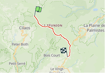
Trail Walking of 18.6 km to be discovered at Réunion, Unknown, Saint-Benoît. This trail is proposed by Ko-Rando.
Description
Du gîte de la Caverne Dufour jusqu'à Bourg Murat.
Partie la plus pluvieuse de la traversée.
Positioning
Country:
France
Region :
Réunion
Department/Province :
Unknown
Municipality :
Saint-Benoît
Location:
Unknown
Start:(Dec)
Start:(UTM)
343812 ; 7664948 (40K) S.
Comments