


MUR PAÏEN MONT STE ODILE

alinetpierre
User
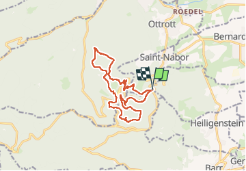

Length
14.3 km

Max alt
831 m

Uphill gradient
522 m
Km-Effort
21 km

Min alt
543 m

Downhill gradient
525 m
Boucle
Yes
Creation date :
2025-06-13 06:54:25.0
Updated on :
2025-06-13 13:18:51.284

FREE GPS app for hiking
 SityTrail
IGN / Geographical institutes
SityTrail Plus
The world is yours!
About
Trail of 14.3 km to be discovered at Grand Est, Bas-Rhin, Obernai. This trail is proposed by alinetpierre.
Description
Domaine St Jacques, Mont Ste Odile Mur Païen sud et nord ,sentier des Merveilles. Amicale CASRA26
Photos


27 photos in total. Please click on a photo to see them all in the gallery.
Positioning
Country:
France
Region :
Grand Est
Department/Province :
Bas-Rhin
Municipality :
Obernai
Location:
Unknown
Start:(Dec)
Start:(UTM)
383004 ; 5365833 (32U) N.
Comments