


2025-06-13_16h13m19_J2G3circuit lac d'Estenc
© OpenStreetMap contributors


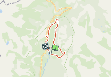
Length
4.8 km
Max alt
1886 m
Uphill gradient
213 m
Km-Effort
7.6 km
Min alt
1694 m
Downhill gradient
205 m
Boucle
Yes
Creation date :
2025-06-13 14:13:19.818
Updated on :
2025-06-13 14:13:21.748
FREE GPS app for hiking
 SityTrail
IGN / Geographical institutes
SityTrail Plus
The world is yours!
About
Trail of 4.8 km to be discovered at Provence-Alpes-Côte d'Azur, Maritime Alps, Entraunes. This trail is proposed by louventouletdu04@hotmail.fr.
Positioning
Country:
France
Region :
Provence-Alpes-Côte d'Azur
Department/Province :
Maritime Alps
Municipality :
Entraunes
Location:
Unknown
Start:(Dec)
Start:(UTM)
320656 ; 4899987 (32T) N.
Comments