


2025 06 14 Pont Audemer

chlafaille
User
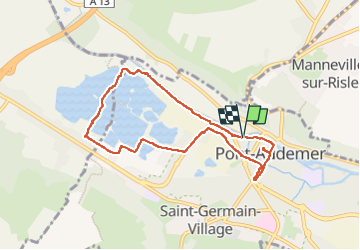

Length
7.3 km

Max alt
15 m

Uphill gradient
32 m
Km-Effort
7.7 km

Min alt
-3 m

Downhill gradient
32 m
Boucle
Yes
Creation date :
2025-06-14 13:40:52.283
Updated on :
2025-06-14 15:25:11.423
1h44
Difficulty : Very easy

FREE GPS app for hiking
 SityTrail
IGN / Geographical institutes
SityTrail Plus
The world is yours!
About
Trail Walking of 7.3 km to be discovered at Normandy, Eure, Pont-Audemer. This trail is proposed by chlafaille.
Positioning
Country:
France
Region :
Normandy
Department/Province :
Eure
Municipality :
Pont-Audemer
Location:
Pont-Audemer
Start:(Dec)
Start:(UTM)
319247 ; 5470240 (31U) N.
Comments