


2025-06-15_08h11m09_Parcours 18km_Bortis Trail-2025 3

Papy Diouf
User

Length
18.3 km

Max alt
142 m

Uphill gradient
382 m
Km-Effort
23 km

Min alt
27 m

Downhill gradient
383 m
Boucle
Yes
Creation date :
2025-06-15 06:11:09.13
Updated on :
2025-06-15 06:11:10.344

FREE GPS app for hiking
 SityTrail
IGN / Geographical institutes
SityTrail Plus
The world is yours!
About
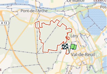
Trail of 18.3 km to be discovered at Normandy, Eure, Val-de-Reuil. This trail is proposed by Papy Diouf.
Positioning
Country:
France
Region :
Normandy
Department/Province :
Eure
Municipality :
Val-de-Reuil
Location:
Unknown
Start:(Dec)
Start:(UTM)
368859 ; 5459327 (31U) N.
Comments