


PRALOGNAN/REFUGE CO0L DE LA VANOISE (6 Km, 845 m d+).

DUCLUZEAU
User
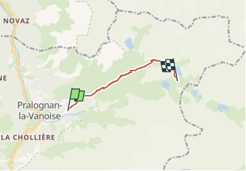

Length
6 km

Max alt
2517 m

Uphill gradient
844 m
Km-Effort
14.5 km

Min alt
1660 m

Downhill gradient
1 m
Boucle
No
Creation date :
2025-06-16 14:17:34.164
Updated on :
2025-06-16 14:19:03.606
3h17
Difficulty : Medium

FREE GPS app for hiking
 SityTrail
IGN / Geographical institutes
SityTrail Plus
The world is yours!
About
Trail Walking of 6 km to be discovered at Auvergne-Rhône-Alpes, Savoy, Pralognan-la-Vanoise. This trail is proposed by DUCLUZEAU.
Positioning
Country:
France
Region :
Auvergne-Rhône-Alpes
Department/Province :
Savoy
Municipality :
Pralognan-la-Vanoise
Location:
Unknown
Start:(Dec)
Start:(UTM)
322723 ; 5027864 (32T) N.
Comments