


REFUGE COL VANOISE/REFUGE ARPONT ( 450 m d+, 655 m d-).

DUCLUZEAU
User
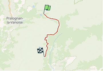

Length
14.1 km

Max alt
2580 m

Uphill gradient
445 m
Km-Effort
21 km

Min alt
2297 m

Downhill gradient
654 m
Boucle
No
Creation date :
2025-06-16 14:20:11.394
Updated on :
2025-06-16 14:22:10.953
4h43
Difficulty : Difficult

FREE GPS app for hiking
 SityTrail
IGN / Geographical institutes
SityTrail Plus
The world is yours!
About
Trail Walking of 14.1 km to be discovered at Auvergne-Rhône-Alpes, Savoy, Pralognan-la-Vanoise. This trail is proposed by DUCLUZEAU.
Positioning
Country:
France
Region :
Auvergne-Rhône-Alpes
Department/Province :
Savoy
Municipality :
Pralognan-la-Vanoise
Location:
Unknown
Start:(Dec)
Start:(UTM)
327083 ; 5028895 (32T) N.
Comments