


REFUGE ARPONT/REFUGE AUSSOIS (20 Km, 1050 m d+, 1000 m d-).

DUCLUZEAU
User
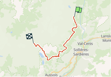

Length
20 km

Max alt
2527 m

Uphill gradient
1041 m
Km-Effort
34 km

Min alt
2071 m

Downhill gradient
994 m
Boucle
No
Creation date :
2025-06-16 14:23:24.537
Updated on :
2025-06-16 14:25:04.504
7h42
Difficulty : Very difficult

FREE GPS app for hiking
 SityTrail
IGN / Geographical institutes
SityTrail Plus
The world is yours!
About
Trail Walking of 20 km to be discovered at Auvergne-Rhône-Alpes, Savoy, Val-Cenis. This trail is proposed by DUCLUZEAU.
Positioning
Country:
France
Region :
Auvergne-Rhône-Alpes
Department/Province :
Savoy
Municipality :
Val-Cenis
Location:
Termignon
Start:(Dec)
Start:(UTM)
327046 ; 5020776 (32T) N.
Comments