


Andenne CalvaireChawagne LesAgresses Boisd’Heer

thomarche
User
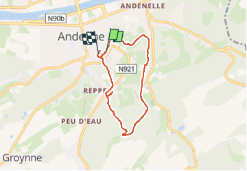

Length
6.3 km

Max alt
226 m

Uphill gradient
185 m
Km-Effort
8.9 km

Min alt
83 m

Downhill gradient
212 m
Boucle
Yes
Creation date :
2025-06-17 09:08:47.0
Updated on :
2025-06-17 14:31:10.845
4h49
Difficulty : Easy

FREE GPS app for hiking
 SityTrail
IGN / Geographical institutes
SityTrail Plus
The world is yours!
About
Trail Walking of 6.3 km to be discovered at Wallonia, Namur, Andenne. This trail is proposed by thomarche.
Description
Boucle sympa. Dénivelé. Vue de la chapelle du calvaire. Très beaux arbres. A la fin, petit demi-tour sentier ok sur carte, barré par nouvelle maison (tronçon effectivement rouge sur chemins.be).
Positioning
Country:
Belgium
Region :
Wallonia
Department/Province :
Namur
Municipality :
Andenne
Location:
Unknown
Start:(Dec)
Start:(UTM)
649183 ; 5594893 (31U) N.
Comments