


evian thonon trajet train et rando

ISAGIL
User
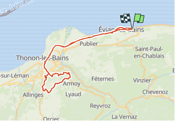

Length
38 km

Max alt
628 m

Uphill gradient
541 m
Km-Effort
45 km

Min alt
370 m

Downhill gradient
542 m
Boucle
Yes
Creation date :
2025-06-19 07:24:30.601
Updated on :
2025-06-19 15:18:29.561
7h52
Difficulty : Very difficult

FREE GPS app for hiking
 SityTrail
IGN / Geographical institutes
SityTrail Plus
The world is yours!
About
Trail Walking of 38 km to be discovered at Auvergne-Rhône-Alpes, Upper Savoy, Évian-les-Bains. This trail is proposed by ISAGIL.
Positioning
Country:
France
Region :
Auvergne-Rhône-Alpes
Department/Province :
Upper Savoy
Municipality :
Évian-les-Bains
Location:
Unknown
Start:(Dec)
Start:(UTM)
315914 ; 5141385 (32T) N.
Comments