


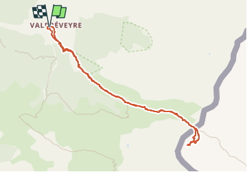
Queyras : A/R Col d'Urine, Tête du Pelvas

manumax
User

Length
9.8 km

Max alt
2723 m

Uphill gradient
864 m
Km-Effort
21 km

Min alt
1853 m

Downhill gradient
865 m
Boucle
Yes
Creation date :
2025-06-19 06:44:30.336
Updated on :
2025-06-21 20:26:32.688
5h50
Difficulty : Very difficult

FREE GPS app for hiking
 SityTrail
IGN / Geographical institutes
SityTrail Plus
The world is yours!
About
Trail Walking of 9.8 km to be discovered at Provence-Alpes-Côte d'Azur, Hautes-Alpes, Abriès-Ristolas. This trail is proposed by manumax.
Description
Allée et retour jusqu'à la tête du Pelvas
Fait le 19/06/2025
Positioning
Country:
France
Region :
Provence-Alpes-Côte d'Azur
Department/Province :
Hautes-Alpes
Municipality :
Abriès-Ristolas
Location:
Abriès
Start:(Dec)
Start:(UTM)
339304 ; 4964099 (32T) N.
Comments