


signal

jpgo73
User

Length
10.4 km

Max alt
1495 m

Uphill gradient
216 m
Km-Effort
13.2 km

Min alt
1429 m

Downhill gradient
213 m
Boucle
Yes
Creation date :
2025-06-18 12:09:27.136
Updated on :
2025-06-20 09:44:16.127
45h24
Difficulty : Difficult

FREE GPS app for hiking
 SityTrail
IGN / Geographical institutes
SityTrail Plus
The world is yours!
About
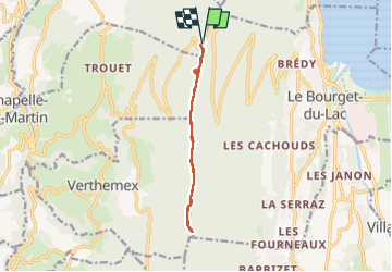
Trail Walking of 10.4 km to be discovered at Auvergne-Rhône-Alpes, Savoy, Saint-Paul. This trail is proposed by jpgo73.
Photos

Positioning
Country:
France
Region :
Auvergne-Rhône-Alpes
Department/Province :
Savoy
Municipality :
Saint-Paul
Location:
Unknown
Start:(Dec)
Start:(UTM)
719766 ; 5060223 (31T) N.
Comments