


les saisies 20 juin

Valmeinier
User
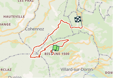

Length
15.4 km

Max alt
1935 m

Uphill gradient
715 m
Km-Effort
25 km

Min alt
1478 m

Downhill gradient
624 m
Boucle
No
Creation date :
2025-06-20 07:08:21.135
Updated on :
2025-06-20 12:25:59.168
5h15
Difficulty : Very difficult

FREE GPS app for hiking
 SityTrail
IGN / Geographical institutes
SityTrail Plus
The world is yours!
About
Trail Walking of 15.4 km to be discovered at Auvergne-Rhône-Alpes, Savoy, Villard-sur-Doron. This trail is proposed by Valmeinier.
Positioning
Country:
France
Region :
Auvergne-Rhône-Alpes
Department/Province :
Savoy
Municipality :
Villard-sur-Doron
Location:
Unknown
Start:(Dec)
Start:(UTM)
305521 ; 5067878 (32T) N.
Comments