


Arthès Saint-Juéry Les Avalats en boucle

tercla
User
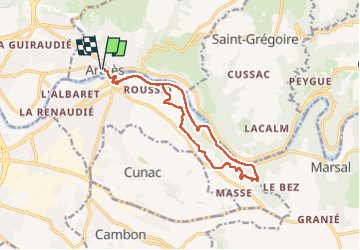

Length
15 km

Max alt
298 m

Uphill gradient
292 m
Km-Effort
18.8 km

Min alt
156 m

Downhill gradient
291 m
Boucle
Yes
Creation date :
2025-06-21 06:33:03.098
Updated on :
2025-06-21 10:38:53.707
3h52
Difficulty : Medium

FREE GPS app for hiking
 SityTrail
IGN / Geographical institutes
SityTrail Plus
The world is yours!
About
Trail Walking of 15 km to be discovered at Occitania, Tarn, Arthès. This trail is proposed by tercla.
Photos


Positioning
Country:
France
Region :
Occitania
Department/Province :
Tarn
Municipality :
Arthès
Location:
Unknown
Start:(Dec)
Start:(UTM)
436383 ; 4867071 (31T) N.
Comments