


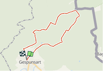
gespunt amis du parc

Michel Leriche 08
User

Length
8.1 km

Max alt
367 m

Uphill gradient
278 m
Km-Effort
11.8 km

Min alt
203 m

Downhill gradient
278 m
Boucle
Yes
Creation date :
2025-06-21 12:01:00.389
Updated on :
2025-06-21 16:48:36.216
3h30
Difficulty : Medium

FREE GPS app for hiking
 SityTrail
IGN / Geographical institutes
SityTrail Plus
The world is yours!
About
Trail Walking of 8.1 km to be discovered at Grand Est, Ardennes, Gespunsart. This trail is proposed by Michel Leriche 08.
Description
facile
Positioning
Country:
France
Region :
Grand Est
Department/Province :
Ardennes
Municipality :
Gespunsart
Location:
Unknown
Start:(Dec)
Start:(UTM)
631444 ; 5520410 (31U) N.
Comments