


Rando boucle St Vaast lès Mello

sebastienu
User
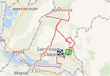

Length
11.4 km

Max alt
117 m

Uphill gradient
164 m
Km-Effort
13.6 km

Min alt
33 m

Downhill gradient
164 m
Boucle
Yes
Creation date :
2025-06-22 08:30:55.748
Updated on :
2025-06-22 14:15:22.914
5h43
Difficulty : Difficult

FREE GPS app for hiking
 SityTrail
IGN / Geographical institutes
SityTrail Plus
The world is yours!
About
Trail Walking of 11.4 km to be discovered at Hauts-de-France, Oise, Saint-Vaast-lès-Mello. This trail is proposed by sebastienu.
Description
Carrières
Positioning
Country:
France
Region :
Hauts-de-France
Department/Province :
Oise
Municipality :
Saint-Vaast-lès-Mello
Location:
Unknown
Start:(Dec)
Start:(UTM)
456170 ; 5457029 (31U) N.
Comments