


J1

PhilippeC54
User
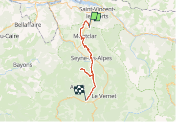

Length
41 km

Max alt
1535 m

Uphill gradient
1121 m
Km-Effort
57 km

Min alt
1108 m

Downhill gradient
1322 m
Boucle
No
Creation date :
2025-06-22 08:43:54.429
Updated on :
2025-06-22 15:58:50.083
3h49
Difficulty : Difficult

FREE GPS app for hiking
 SityTrail
IGN / Geographical institutes
SityTrail Plus
The world is yours!
About
Trail Mountain bike of 41 km to be discovered at Provence-Alpes-Côte d'Azur, Alpes-de-Haute-Provence, Montclar. This trail is proposed by PhilippeC54.
Positioning
Country:
France
Region :
Provence-Alpes-Côte d'Azur
Department/Province :
Alpes-de-Haute-Provence
Municipality :
Montclar
Location:
Unknown
Start:(Dec)
Start:(UTM)
288982 ; 4921154 (32T) N.
Comments