


Marché Pantin

pantin
User
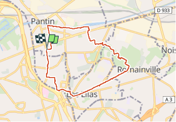

Length
7.8 km

Max alt
130 m

Uphill gradient
101 m
Km-Effort
9.1 km

Min alt
50 m

Downhill gradient
103 m
Boucle
Yes
Creation date :
2025-06-22 14:32:48.0
Updated on :
2025-06-22 17:35:31.745
2h16
Difficulty : Easy

FREE GPS app for hiking
 SityTrail
IGN / Geographical institutes
SityTrail Plus
The world is yours!
About
Trail Walking of 7.8 km to be discovered at Ile-de-France, Seine-Saint-Denis, Pantin. This trail is proposed by pantin.
Positioning
Country:
France
Region :
Ile-de-France
Department/Province :
Seine-Saint-Denis
Municipality :
Pantin
Location:
Unknown
Start:(Dec)
Start:(UTM)
456271 ; 5415382 (31U) N.
Comments