


OR-8104320--Lay-Saint-Christophe:Les 2 étangs (11 kms)

noelphil
User
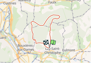

Length
11.4 km

Max alt
362 m

Uphill gradient
261 m
Km-Effort
14.9 km

Min alt
207 m

Downhill gradient
259 m
Boucle
Yes
Creation date :
2025-06-23 05:43:10.605
Updated on :
2025-06-23 05:43:36.236
3h22
Difficulty : Difficult

FREE GPS app for hiking
 SityTrail
IGN / Geographical institutes
SityTrail Plus
The world is yours!
About
Trail Walking of 11.4 km to be discovered at Grand Est, Meurthe-et-Moselle, Lay-Saint-Christophe. This trail is proposed by noelphil.
Positioning
Country:
France
Region :
Grand Est
Department/Province :
Meurthe-et-Moselle
Municipality :
Lay-Saint-Christophe
Location:
Unknown
Start:(Dec)
Start:(UTM)
293956 ; 5403549 (32U) N.
Comments