


Père TACOT-La pte Lande-Chênedet 18km JY

COGLAIS3
User

Length
17.7 km

Max alt
207 m

Uphill gradient
237 m
Km-Effort
21 km

Min alt
131 m

Downhill gradient
238 m
Boucle
Yes
Creation date :
2025-06-24 06:15:31.474
Updated on :
2025-06-29 16:16:00.805
3h27
Difficulty : Very easy

FREE GPS app for hiking
 SityTrail
IGN / Geographical institutes
SityTrail Plus
The world is yours!
About
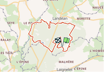
Trail Nordic walking of 17.7 km to be discovered at Brittany, Ille-et-Vilaine, Landéan. This trail is proposed by COGLAIS3.
Positioning
Country:
France
Region :
Brittany
Department/Province :
Ille-et-Vilaine
Municipality :
Landéan
Location:
Unknown
Start:(Dec)
Start:(UTM)
636951 ; 5361235 (30U) N.
Comments