


J4

PhilippeC54
User
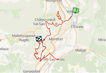

Length
51 km

Max alt
735 m

Uphill gradient
1263 m
Km-Effort
68 km

Min alt
393 m

Downhill gradient
1179 m
Boucle
No
Creation date :
2025-06-25 06:56:54.073
Updated on :
2025-06-25 19:40:55.102
4h17
Difficulty : Very difficult

FREE GPS app for hiking
 SityTrail
IGN / Geographical institutes
SityTrail Plus
The world is yours!
About
Trail Mountain bike of 51 km to be discovered at Provence-Alpes-Côte d'Azur, Alpes-de-Haute-Provence, Château-Arnoux-Saint-Auban. This trail is proposed by PhilippeC54.
Positioning
Country:
France
Region :
Provence-Alpes-Côte d'Azur
Department/Province :
Alpes-de-Haute-Provence
Municipality :
Château-Arnoux-Saint-Auban
Location:
Unknown
Start:(Dec)
Start:(UTM)
260700 ; 4887430 (32T) N.
Comments