


château de montlosier puy Vichatel

jeanic63
User
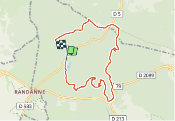

Length
9 km

Max alt
1086 m

Uphill gradient
226 m
Km-Effort
11.9 km

Min alt
952 m

Downhill gradient
221 m
Boucle
Yes
Creation date :
2025-06-26 06:36:35.368
Updated on :
2025-06-29 13:37:57.019
2h27
Difficulty : Medium

FREE GPS app for hiking
 SityTrail
IGN / Geographical institutes
SityTrail Plus
The world is yours!
About
Trail Walking of 9 km to be discovered at Auvergne-Rhône-Alpes, Puy-de-Dôme, Aydat. This trail is proposed by jeanic63.
Description
départ château de montlosier
Positioning
Country:
France
Region :
Auvergne-Rhône-Alpes
Department/Province :
Puy-de-Dôme
Municipality :
Aydat
Location:
Unknown
Start:(Dec)
Start:(UTM)
496186 ; 5059868 (31T) N.
Comments