


Trelins

ramsay
User
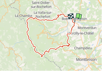

Length
76 km

Max alt
1609 m

Uphill gradient
2111 m
Km-Effort
104 km

Min alt
405 m

Downhill gradient
2120 m
Boucle
Yes
Creation date :
2015-07-28 00:00:00.0
Updated on :
2015-07-28 00:00:00.0
--
Difficulty : Difficult

FREE GPS app for hiking
 SityTrail
IGN / Geographical institutes
SityTrail Plus
The world is yours!
About
Trail Mountain bike of 76 km to be discovered at Auvergne-Rhône-Alpes, Loire, Trelins. This trail is proposed by ramsay.
Description
Pierre sur Haute 75 km
Positioning
Country:
France
Region :
Auvergne-Rhône-Alpes
Department/Province :
Loire
Municipality :
Trelins
Location:
Unknown
Start:(Dec)
Start:(UTM)
578399 ; 5064793 (31T) N.
Comments