


250628 - Vendes - Vendes=>VVF

randodan
User
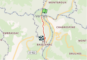

Length
2 km

Max alt
494 m

Uphill gradient
122 m
Km-Effort
3.3 km

Min alt
371 m

Downhill gradient
24 m
Boucle
No
Creation date :
2025-06-28 07:34:34.608
Updated on :
2025-06-28 08:38:12.677
1h03
Difficulty : Easy

FREE GPS app for hiking
 SityTrail
IGN / Geographical institutes
SityTrail Plus
The world is yours!
About
Trail Walking of 2 km to be discovered at Auvergne-Rhône-Alpes, Cantal, Bassignac. This trail is proposed by randodan.
Positioning
Country:
France
Region :
Auvergne-Rhône-Alpes
Department/Province :
Cantal
Municipality :
Bassignac
Location:
Unknown
Start:(Dec)
Start:(UTM)
451856 ; 5016116 (31T) N.
Comments