


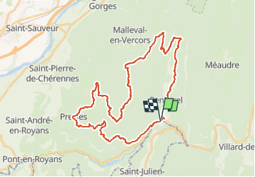
Vercors- La Chapelle-Les Coulmes-Rencurel

nicolas54230
User

Length
42 km

Max alt
1440 m

Uphill gradient
1641 m
Km-Effort
64 km

Min alt
655 m

Downhill gradient
1646 m
Boucle
Yes
Creation date :
2025-06-28 15:39:39.529
Updated on :
2025-06-28 15:40:32.85
4h27
Difficulty : Very difficult

FREE GPS app for hiking
 SityTrail
IGN / Geographical institutes
SityTrail Plus
The world is yours!
About
Trail Mountain bike of 42 km to be discovered at Auvergne-Rhône-Alpes, Isère, Rencurel. This trail is proposed by nicolas54230.
Positioning
Country:
France
Region :
Auvergne-Rhône-Alpes
Department/Province :
Isère
Municipality :
Rencurel
Location:
Unknown
Start:(Dec)
Start:(UTM)
694207 ; 4995715 (31T) N.
Comments