


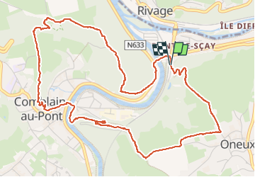
pont sçay - comblain-au-pont / versant sud - retour versant nord

stef789
User GUIDE

Length
6.4 km

Max alt
209 m

Uphill gradient
207 m
Km-Effort
9.2 km

Min alt
96 m

Downhill gradient
214 m
Boucle
Yes
Creation date :
2025-06-28 13:42:30.702
Updated on :
2025-06-28 17:19:11.394
3h36
Difficulty : Medium

FREE GPS app for hiking
 SityTrail
IGN / Geographical institutes
SityTrail Plus
The world is yours!
About
Trail Walking of 6.4 km to be discovered at Wallonia, Liège, Comblain-au-Pont. This trail is proposed by stef789.
Photos


34 photos in total. Please click on a photo to see them all in the gallery.
Positioning
Country:
Belgium
Region :
Wallonia
Department/Province :
Liège
Municipality :
Comblain-au-Pont
Location:
Unknown
Start:(Dec)
Start:(UTM)
683795 ; 5595105 (31U) N.
Comments