


co

Laurent53
User

Length
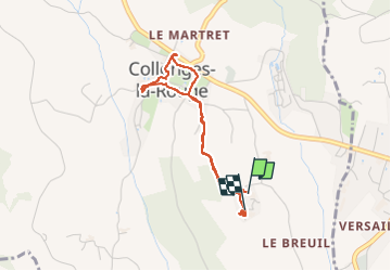
3.3 km

Max alt
234 m

Uphill gradient
73 m
Km-Effort
4.3 km

Min alt
180 m

Downhill gradient
84 m
Boucle
Yes
Creation date :
2025-06-29 07:00:29.256
Updated on :
2025-06-29 08:47:17.763
1h35
Difficulty : Easy

FREE GPS app for hiking
 SityTrail
IGN / Geographical institutes
SityTrail Plus
The world is yours!
About
Trail Walking of 3.3 km to be discovered at New Aquitaine, Corrèze, Collonges-la-Rouge. This trail is proposed by Laurent53.
Positioning
Country:
France
Region :
New Aquitaine
Department/Province :
Corrèze
Municipality :
Collonges-la-Rouge
Location:
Unknown
Start:(Dec)
Start:(UTM)
394580 ; 4989834 (31T) N.
Comments