


2015-07-28 J1 St-Jean-pied-de-port à St-Etienne-de-Baigorry

raphael94
User
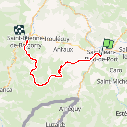

Length
21 km

Max alt
1015 m

Uphill gradient
1016 m
Km-Effort
34 km

Min alt
155 m

Downhill gradient
1022 m
Boucle
No
Creation date :
2015-08-08 00:00:00.0
Updated on :
2015-08-08 00:00:00.0
6h13
Difficulty : Unknown

FREE GPS app for hiking
 SityTrail
IGN / Geographical institutes
SityTrail Plus
The world is yours!
About
Trail Walking of 21 km to be discovered at New Aquitaine, Pyrénées-Atlantiques, Saint-Jean-Pied-de-Port. This trail is proposed by raphael94.
Positioning
Country:
France
Region :
New Aquitaine
Department/Province :
Pyrénées-Atlantiques
Municipality :
Saint-Jean-Pied-de-Port
Location:
Unknown
Start:(Dec)
Start:(UTM)
643267 ; 4780411 (30T) N.
Comments