


T-og-Lac de Soliet

Jack-94
User
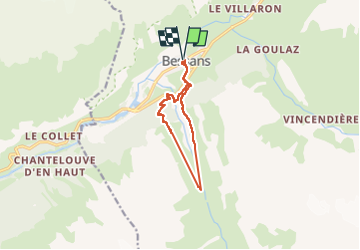

Length
9.8 km

Max alt
2149 m

Uphill gradient
482 m
Km-Effort
16.3 km

Min alt
1708 m

Downhill gradient
482 m
Boucle
Yes
Creation date :
2025-06-29 07:55:53.532
Updated on :
2025-06-29 13:29:17.057
5h33
Difficulty : Difficult

FREE GPS app for hiking
 SityTrail
IGN / Geographical institutes
SityTrail Plus
The world is yours!
About
Trail Walking of 9.8 km to be discovered at Auvergne-Rhône-Alpes, Savoy, Bessans. This trail is proposed by Jack-94.
Positioning
Country:
France
Region :
Auvergne-Rhône-Alpes
Department/Province :
Savoy
Municipality :
Bessans
Location:
Unknown
Start:(Dec)
Start:(UTM)
342702 ; 5020548 (32T) N.
Comments