


T-JG-Lac-De-Soliet

Jack-94
User
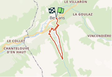

Length
10.6 km

Max alt
2131 m

Uphill gradient
453 m
Km-Effort
16.6 km

Min alt
1708 m

Downhill gradient
452 m
Boucle
Yes
Creation date :
2025-06-29 07:58:41.879
Updated on :
2025-06-29 13:30:16.02
5h31
Difficulty : Difficult

FREE GPS app for hiking
 SityTrail
IGN / Geographical institutes
SityTrail Plus
The world is yours!
About
Trail Walking of 10.6 km to be discovered at Auvergne-Rhône-Alpes, Savoy, Bessans. This trail is proposed by Jack-94.

Positioning
Country:
France
Region :
Auvergne-Rhône-Alpes
Department/Province :
Savoy
Municipality :
Bessans
Location:
Unknown
Start:(Dec)
Start:(UTM)
342704 ; 5020549 (32T) N.
Comments