


vaulmier fin

coglais
User
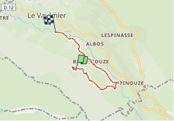

Length
4.9 km

Max alt
1013 m

Uphill gradient
34 m
Km-Effort
6.2 km

Min alt
756 m

Downhill gradient
284 m
Boucle
No
Creation date :
2025-06-29 11:49:33.175
Updated on :
2025-06-29 13:37:54.326
1h15
Difficulty : Very easy

FREE GPS app for hiking
 SityTrail
IGN / Geographical institutes
SityTrail Plus
The world is yours!
About
Trail Nordic walking of 4.9 km to be discovered at Auvergne-Rhône-Alpes, Cantal, Le Vaulmier. This trail is proposed by coglais.
Positioning
Country:
France
Region :
Auvergne-Rhône-Alpes
Department/Province :
Cantal
Municipality :
Le Vaulmier
Location:
Unknown
Start:(Dec)
Start:(UTM)
466871 ; 5002529 (31T) N.
Comments