


Tour du lac du Bouchet

7217Lionel
User
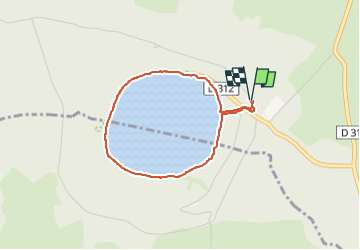

Length
3.1 km

Max alt
1243 m

Uphill gradient
48 m
Km-Effort
3.8 km

Min alt
1208 m

Downhill gradient
47 m
Boucle
Yes
Creation date :
2025-07-01 13:57:53.927
Updated on :
2025-07-01 14:59:28.461
1h01
Difficulty : Easy

FREE GPS app for hiking
 SityTrail
IGN / Geographical institutes
SityTrail Plus
The world is yours!
About
Trail Walking of 3.1 km to be discovered at Auvergne-Rhône-Alpes, Haute-Loire, Cayres. This trail is proposed by 7217Lionel.
Positioning
Country:
France
Region :
Auvergne-Rhône-Alpes
Department/Province :
Haute-Loire
Municipality :
Cayres
Location:
Unknown
Start:(Dec)
Start:(UTM)
562978 ; 4973317 (31T) N.
Comments