


Fin J 1:

DUCLUZEAU
User
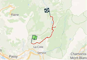

Length
14.8 km

Max alt
2436 m

Uphill gradient
1269 m
Km-Effort
30 km

Min alt
1295 m

Downhill gradient
806 m
Boucle
No
Creation date :
2025-07-03 11:41:41.898
Updated on :
2025-07-03 11:41:44.519
6h51
Difficulty : Very difficult

FREE GPS app for hiking
 SityTrail
IGN / Geographical institutes
SityTrail Plus
The world is yours!
About
Trail Walking of 14.8 km to be discovered at Auvergne-Rhône-Alpes, Upper Savoy, Passy. This trail is proposed by DUCLUZEAU.
Positioning
Country:
France
Region :
Auvergne-Rhône-Alpes
Department/Province :
Upper Savoy
Municipality :
Passy
Location:
Unknown
Start:(Dec)
Start:(UTM)
324661 ; 5091061 (32T) N.
Comments