


2015-07-29 J2 St-Etienne-de-Baigorry à Bidarray

raphael94
User
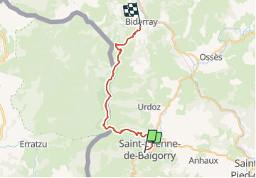

Length
20 km

Max alt
1037 m

Uphill gradient
1254 m
Km-Effort
37 km

Min alt
141 m

Downhill gradient
1271 m
Boucle
No
Creation date :
2015-08-08 00:00:00.0
Updated on :
2015-08-08 00:00:00.0
7h32
Difficulty : Unknown

FREE GPS app for hiking
 SityTrail
IGN / Geographical institutes
SityTrail Plus
The world is yours!
About
Trail Walking of 20 km to be discovered at New Aquitaine, Pyrénées-Atlantiques, Saint-Étienne-de-Baïgorry. This trail is proposed by raphael94.
Positioning
Country:
France
Region :
New Aquitaine
Department/Province :
Pyrénées-Atlantiques
Municipality :
Saint-Étienne-de-Baïgorry
Location:
Unknown
Start:(Dec)
Start:(UTM)
634258 ; 4781528 (30T) N.
Comments