


cascade de la dore

kiavtt
User
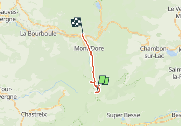

Length
9.5 km

Max alt
1660 m

Uphill gradient
39 m
Km-Effort
12.1 km

Min alt
997 m

Downhill gradient
667 m
Boucle
No
Creation date :
2025-07-04 17:09:48.059
Updated on :
2025-07-04 20:11:57.38
3h00
Difficulty : Medium

FREE GPS app for hiking
 SityTrail
IGN / Geographical institutes
SityTrail Plus
The world is yours!
About
Trail Walking of 9.5 km to be discovered at Auvergne-Rhône-Alpes, Puy-de-Dôme, Mont-Dore. This trail is proposed by kiavtt.
Description
voiture jusqu'à station du Mont Dore puis randonnée jusqu'au petits ruisseaux de la source juste au dessus de la cascade
Accès interdit pour voir la chute
Positioning
Country:
France
Region :
Auvergne-Rhône-Alpes
Department/Province :
Puy-de-Dôme
Municipality :
Mont-Dore
Location:
Unknown
Start:(Dec)
Start:(UTM)
485976 ; 5042221 (31T) N.
Comments