


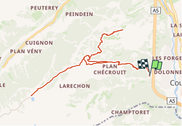
Aller retour : Courmayeur ➡️ Mont Chétif ➡️ Lac Checrouit

lbuteux
User


3h00
Difficulty : Difficult

FREE GPS app for hiking
 SityTrail
IGN / Geographical institutes
SityTrail Plus
The world is yours!
About
Trail Trail of 12.7 km to be discovered at Aosta Valley, Unknown, Courmayeur. This trail is proposed by lbuteux.
Description
Départ musclé ↗️ 5km/1000d Mont Chétif, mais ça vaut la peine : Vue magnifique sur la chaîne du Mont Blanc. A mi descente, j'ai voulu voir le lac Checrouit, pas terrible car beaucoup d'infrastructures de ski, mais la vue sur la Chaîne du Mont Blanc est fantastique. Puis final ↘️ 👌.
A l'arrivée, vous avez le restaurant Lo sciatore, une cuisine locale délicieuse
Positioning
Comments