


T-JG-R1

Jack-94
User
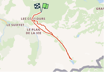

Length
15.4 km

Max alt
2456 m

Uphill gradient
512 m
Km-Effort
22 km

Min alt
2134 m

Downhill gradient
512 m
Boucle
Yes
Creation date :
2025-07-04 08:07:16.416
Updated on :
2025-07-05 15:52:13.41
6h51
Difficulty : Very difficult

FREE GPS app for hiking
 SityTrail
IGN / Geographical institutes
SityTrail Plus
The world is yours!
About
Trail Walking of 15.4 km to be discovered at Auvergne-Rhône-Alpes, Savoy, Val-Cenis. This trail is proposed by Jack-94.
Positioning
Country:
France
Region :
Auvergne-Rhône-Alpes
Department/Province :
Savoy
Municipality :
Val-Cenis
Location:
Bramans
Start:(Dec)
Start:(UTM)
333286 ; 5009223 (32T) N.
Comments