


T-OG-R14

Jack-94
User
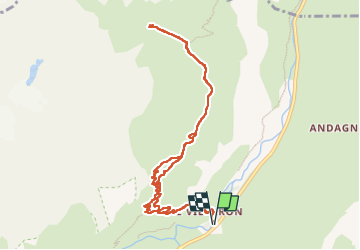

Length
10.8 km

Max alt
2290 m

Uphill gradient
634 m
Km-Effort
19.3 km

Min alt
1733 m

Downhill gradient
634 m
Boucle
Yes
Creation date :
2025-07-06 07:04:56.935
Updated on :
2025-07-06 13:14:24.093
6h08
Difficulty : Very difficult

FREE GPS app for hiking
 SityTrail
IGN / Geographical institutes
SityTrail Plus
The world is yours!
About
Trail Walking of 10.8 km to be discovered at Auvergne-Rhône-Alpes, Savoy, Bessans. This trail is proposed by Jack-94.
Positioning
Country:
France
Region :
Auvergne-Rhône-Alpes
Department/Province :
Savoy
Municipality :
Bessans
Location:
Unknown
Start:(Dec)
Start:(UTM)
344521 ; 5021714 (32T) N.
Comments