


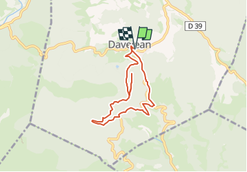
La petite rando de Davejean

SoleilMoussanais
User


3h00
Difficulty : Easy

FREE GPS app for hiking
 SityTrail
IGN / Geographical institutes
SityTrail Plus
The world is yours!
About
Trail Walking of 6.9 km to be discovered at Occitania, Aude, Davejean. This trail is proposed by SoleilMoussanais.
Description
Découverte d'un ancien site d'extraction d'argile,passage au Moulin de la Valette, contempler les glacis quaternaires accrochés aux parois de l'abri sous roche, aller au point de vue à 360 ° (Valmigère, Nitable Roc, Pla de Ferriol, Davejean, Mont Tauch...). Terminer par la Place de l'Ayral et sa fontaine, visite de l'église autrefois castrale ( XIe-XIVe siècles)
Positioning
Comments