


plage bangor

benoitrando
User
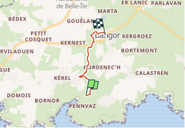

Length
2.7 km

Max alt
50 m

Uphill gradient
69 m
Km-Effort
3.5 km

Min alt
7 m

Downhill gradient
28 m
Boucle
No
Creation date :
2025-07-07 13:28:50.904
Updated on :
2025-07-07 14:04:04.445
34m
Difficulty : Very easy

FREE GPS app for hiking
 SityTrail
IGN / Geographical institutes
SityTrail Plus
The world is yours!
About
Trail Walking of 2.7 km to be discovered at Brittany, Morbihan, Bangor. This trail is proposed by benoitrando.
Description
ombrage agreable en montee
Positioning
Country:
France
Region :
Brittany
Department/Province :
Morbihan
Municipality :
Bangor
Location:
Unknown
Start:(Dec)
Start:(UTM)
485210 ; 5238657 (30T) N.
Comments