


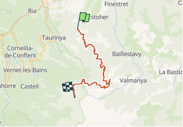
Canigou

babouille
User

Length
22 km

Max alt
2681 m

Uphill gradient
2145 m
Km-Effort
44 km

Min alt
619 m

Downhill gradient
92 m
Boucle
No
Creation date :
2025-06-29 05:58:15.008
Updated on :
2025-07-07 23:04:25.386
1h30
Difficulty : Very difficult
2h21
Difficulty : Very difficult

FREE GPS app for hiking
 SityTrail
IGN / Geographical institutes
SityTrail Plus
The world is yours!
About
Trail Walking of 22 km to be discovered at Occitania, Pyrénées-Orientales, Clara-Villerach. This trail is proposed by babouille.
Description
20 km en velo électrique 1700 dénivelé
4km randonnée a pieds 700 m dénivelé
Positioning
Country:
France
Region :
Occitania
Department/Province :
Pyrénées-Orientales
Municipality :
Clara-Villerach
Location:
Unknown
Start:(Dec)
Start:(UTM)
455554 ; 4715372 (31T) N.
Comments