


col de la Faucille

aav
User
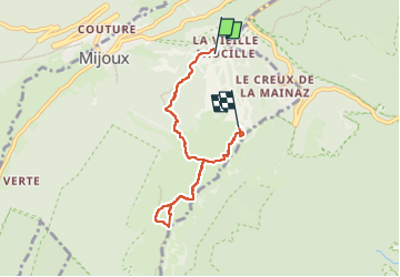

Length
5.8 km

Max alt
1583 m

Uphill gradient
397 m
Km-Effort
10.4 km

Min alt
1325 m

Downhill gradient
202 m
Boucle
No
Creation date :
2025-07-08 09:27:46.0
Updated on :
2025-07-08 12:55:32.68
2h29
Difficulty : Unknown

FREE GPS app for hiking
 SityTrail
IGN / Geographical institutes
SityTrail Plus
The world is yours!
About
Trail Walking of 5.8 km to be discovered at Auvergne-Rhône-Alpes, Ain, Mijoux. This trail is proposed by aav.
Positioning
Country:
France
Region :
Auvergne-Rhône-Alpes
Department/Province :
Ain
Municipality :
Mijoux
Location:
Unknown
Start:(Dec)
Start:(UTM)
270276 ; 5139120 (32T) N.
Comments