


tharon plage étang des gatines

jacq58
User
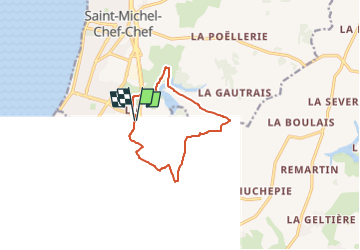

Length
10 km

Max alt
40 m

Uphill gradient
77 m
Km-Effort
11 km

Min alt
7 m

Downhill gradient
75 m
Boucle
Yes
Creation date :
2025-07-09 20:25:04.743
Updated on :
2025-07-09 20:25:06.289
2h30
Difficulty : Medium

FREE GPS app for hiking
 SityTrail
IGN / Geographical institutes
SityTrail Plus
The world is yours!
About
Trail Walking of 10 km to be discovered at Pays de la Loire, Loire-Atlantique, Saint-Michel-Chef-Chef. This trail is proposed by jacq58.
Positioning
Country:
France
Region :
Pays de la Loire
Department/Province :
Loire-Atlantique
Municipality :
Saint-Michel-Chef-Chef
Location:
Unknown
Start:(Dec)
Start:(UTM)
564785 ; 5223170 (30T) N.
Comments