


les passerelles du Monteynard

dansanet
User

Length
18.8 km

Max alt
695 m

Uphill gradient
885 m
Km-Effort
30 km

Min alt
470 m

Downhill gradient
840 m
Boucle
No
Creation date :
2025-07-10 07:45:44.728
Updated on :
2025-07-10 13:59:01.827
6h12
Difficulty : Medium

FREE GPS app for hiking
 SityTrail
IGN / Geographical institutes
SityTrail Plus
The world is yours!
About
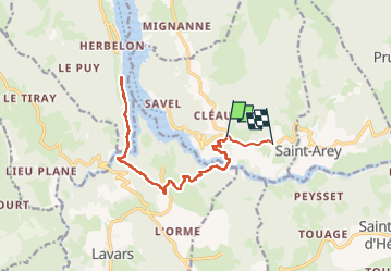
Trail Walking of 18.8 km to be discovered at Auvergne-Rhône-Alpes, Isère, Mayres-Savel. This trail is proposed by dansanet.
Positioning
Country:
France
Region :
Auvergne-Rhône-Alpes
Department/Province :
Isère
Municipality :
Mayres-Savel
Location:
Unknown
Start:(Dec)
Start:(UTM)
713935 ; 4972674 (31T) N.
Comments