


SityTrail - Le Causse Mejean

thonyc
User GUIDE

Length
19.7 km

Max alt
1163 m

Uphill gradient
539 m
Km-Effort
27 km

Min alt
762 m

Downhill gradient
542 m
Boucle
Yes
Creation date :
2025-07-11 13:23:55.582
Updated on :
2025-07-11 13:54:10.224
6h06
Difficulty : Very difficult

FREE GPS app for hiking
 SityTrail
IGN / Geographical institutes
SityTrail Plus
The world is yours!
About
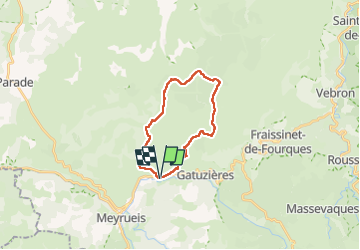
Trail Walking of 19.7 km to be discovered at Occitania, Lozère, Meyrueis. This trail is proposed by thonyc.
Description
Boucle au départ de Salvinsac passant par Aures, Gally, Fretma, La Begude Blanche et Saubert. 20 km et 550 m de dénivelé.
Positioning
Country:
France
Region :
Occitania
Department/Province :
Lozère
Municipality :
Meyrueis
Location:
Unknown
Start:(Dec)
Start:(UTM)
536590 ; 4893834 (31T) N.
Comments