


SityTrail - 4242604 - belle-rando-dans-les-cevennes-

thonyc
User GUIDE
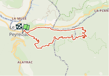

Length
11.2 km

Max alt
842 m

Uphill gradient
635 m
Km-Effort
19.7 km

Min alt
401 m

Downhill gradient
636 m
Boucle
Yes
Creation date :
2025-07-11 13:26:45.367
Updated on :
2025-07-14 13:17:40.633
4h28
Difficulty : Medium

FREE GPS app for hiking
 SityTrail
IGN / Geographical institutes
SityTrail Plus
The world is yours!
About
Trail On foot of 11.2 km to be discovered at Occitania, Aveyron, Peyreleau. This trail is proposed by thonyc.
Description
Décor exceptionnel magnifique y revenir
Positioning
Country:
France
Region :
Occitania
Department/Province :
Aveyron
Municipality :
Peyreleau
Location:
Unknown
Start:(Dec)
Start:(UTM)
516763 ; 4892804 (31T) N.
Comments