


T-JG-R15

Jack-94
User
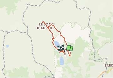

Length
12.2 km

Max alt
2527 m

Uphill gradient
566 m
Km-Effort
19.8 km

Min alt
2024 m

Downhill gradient
566 m
Boucle
Yes
Creation date :
2025-07-09 07:16:54.548
Updated on :
2025-07-11 13:54:42.612
7h31
Difficulty : Very difficult

FREE GPS app for hiking
 SityTrail
IGN / Geographical institutes
SityTrail Plus
The world is yours!
About
Trail Walking of 12.2 km to be discovered at Auvergne-Rhône-Alpes, Savoy, Aussois. This trail is proposed by Jack-94.
Positioning
Country:
France
Region :
Auvergne-Rhône-Alpes
Department/Province :
Savoy
Municipality :
Aussois
Location:
Unknown
Start:(Dec)
Start:(UTM)
321629 ; 5013421 (32T) N.
Comments