


T-OG-R16

Jack-94
User
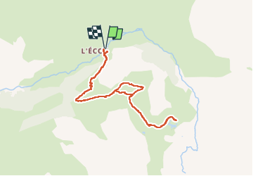

Length
9.3 km

Max alt
2594 m

Uphill gradient
573 m
Km-Effort
17 km

Min alt
2021 m

Downhill gradient
572 m
Boucle
Yes
Creation date :
2025-07-11 07:14:04.085
Updated on :
2025-07-11 13:55:30.789
6h41
Difficulty : Difficult

FREE GPS app for hiking
 SityTrail
IGN / Geographical institutes
SityTrail Plus
The world is yours!
About
Trail Walking of 9.3 km to be discovered at Auvergne-Rhône-Alpes, Savoy, Bonneval-sur-Arc. This trail is proposed by Jack-94.
Positioning
Country:
France
Region :
Auvergne-Rhône-Alpes
Department/Province :
Savoy
Municipality :
Bonneval-sur-Arc
Location:
Unknown
Start:(Dec)
Start:(UTM)
350505 ; 5027003 (32T) N.
Comments