


BALES TIMPLA PIN BAROUSDERE CARDOUET MONR BALRS

OUSSET
User
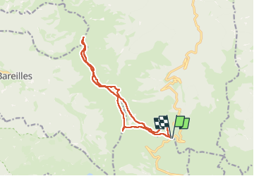

Length
14.9 km

Max alt
2146 m

Uphill gradient
735 m
Km-Effort
25 km

Min alt
1738 m

Downhill gradient
733 m
Boucle
Yes
Creation date :
2025-06-22 06:28:30.766
Updated on :
2025-07-13 15:17:07.25
4h45
Difficulty : Medium

FREE GPS app for hiking
 SityTrail
IGN / Geographical institutes
SityTrail Plus
The world is yours!
About
Trail Walking of 14.9 km to be discovered at Occitania, Haute-Garonne, Bourg-d'Oueil. This trail is proposed by OUSSET.
Positioning
Country:
France
Region :
Occitania
Department/Province :
Haute-Garonne
Municipality :
Bourg-d'Oueil
Location:
Unknown
Start:(Dec)
Start:(UTM)
295860 ; 4749864 (31T) N.
Comments