


mon Calais

stef789
User GUIDE
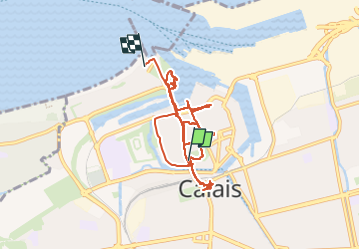

Length
9.6 km

Max alt
13 m

Uphill gradient
70 m
Km-Effort
10.5 km

Min alt
0 m

Downhill gradient
70 m
Boucle
No
Creation date :
2025-07-13 11:32:26.726
Updated on :
2025-07-13 17:37:02.221
4h33
Difficulty : Medium

FREE GPS app for hiking
 SityTrail
IGN / Geographical institutes
SityTrail Plus
The world is yours!
About
Trail Walking of 9.6 km to be discovered at Hauts-de-France, Pas-de-Calais, Calais. This trail is proposed by stef789.
Photos


45 photos in total. Please click on a photo to see them all in the gallery.
Positioning
Country:
France
Region :
Hauts-de-France
Department/Province :
Pas-de-Calais
Municipality :
Calais
Location:
Unknown
Start:(Dec)
Start:(UTM)
419234 ; 5645506 (31U) N.
Comments